“The fact that our weather is often so bad, that’s actually what makes Scottish winter climbing so good,” says mountaineer Simon Richardson in Ephemeral, an excellent 2023 film that documents a single season in the Scottish Highlands (it’s on Amazon Prime's streaming service and well worth a watch). If something is ephemeral, it means that it only lasts for a very short amount of time. The word perfectly sums up the nature of snow and ice conditions found in many of the world’s mountain regions.
When a prolonged freeze brings a prized ice climbing route into being, climbers flock to the scene like moths to a flame. When half a season of freeze-thaw cycles bring about beautiful neve in the gullies, mountaineers are in heaven. Meanwhile, fresh powder might as well be white gold where skiers and snowboarders are concerned.

However, the ephemeral nature of snow and ice also brings danger, most violently exemplified by one of the most feared objective dangers the mountains have to offer: avalanches. When we set out to play in the big, snowy mountains, knowing how to read an avalanche forecast is essential to stay as safe as possible. The ebb and flow of weather conditions, combined with the more punctuated instances of human interaction with the mountains mean that avalanches are, unfortunately, inevitable.
To get you clued up on how to read and avalanche forecast, we asked one of our mountaineering experts to provide this guide, and to point you in the direction of the relevant forecast providers.
How to read an avalanche forecast
Here are 5 steps to take when using an avalanche forecast. For more detail on what each step entails, click the links or scroll down this guide.
1) Consider conditions leading up to the day: knowing how the current conditions have evolved leading up to your adventure is important when making judgements.
2) Read the hazard level: the forecast’s hazard level gives a snapshot of the risk in the mountains on any given day.
3) Read the details that inform the hazard level: the details that underpin the hazard level are crucial, such as guidance around expected avalanche problems, which slopes are most prone, wind speed, freezing level, snow forecast and snowpack conditions.
4) Decide on the best course of action: either choose not to venture into the mountains or pick your route based on available information.
5) Continue your evaluation while on the hill: constantly check that the forecast matches the reality and look for signs of avalanche prone terrain.

It’s worth stating that reading a single avalanche forecast is insufficient when it comes to assessing the complete avalanche hazard. For starters, forecasts are imperfect and should be used as a guide, rather than as gospel truth. Secondly, the forecast usually applies to a large area, giving a general picture of the risk in the region, rather than providing a specific, localized forecast for any given slope.
Then there’s the fact that the forecast is only as good as the person interpreting it. If you’re a seasoned winter mountaineer with experience of assessing avalanche risk while on the hill and you’ve been studying both the season’s snowpack evolution and the forecasts in the lead up to your day, you’ll probably interpret the forecast well. If you’re oblivious to the evolution of snow conditions during the season and you’re a beginner in winter terrain, you’ll not be able to interpret the forecast as effectively.
Safely gaining experience is crucial, which is why hiring a guide or booking a winter skills course is a great way to start your winter walking or mountaineering journey.
Meet the expert
Alex is a qualified Mountain Leader and former President of the London Mountaineering Club. He enjoys both Scottish winter mountaineering and alpine mountaineering, experiences that have given him a strong appreciation of avalanche safety. He's currently working towards becoming a Winter Mountain Leader.
What is an avalanche?
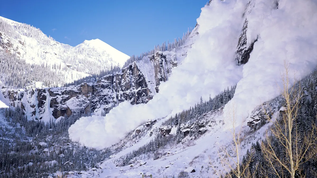
An avalanche is a mass of snow moving downhill, usually at high speed. They occur when the force of gravity acting on a snowpack exceeds the strength of the anchors holding it all together.
The classic image that the mind conjures up is of a roaring plume of ice and snow plummeting down a Himalayan mountain all the way to the valley below, However, avalanches can be much smaller and much more localized, travelling only a short distance. Even the smallest avalanche is dangerous and could be deadly if it knocks you over on rocky or exposed terrain.
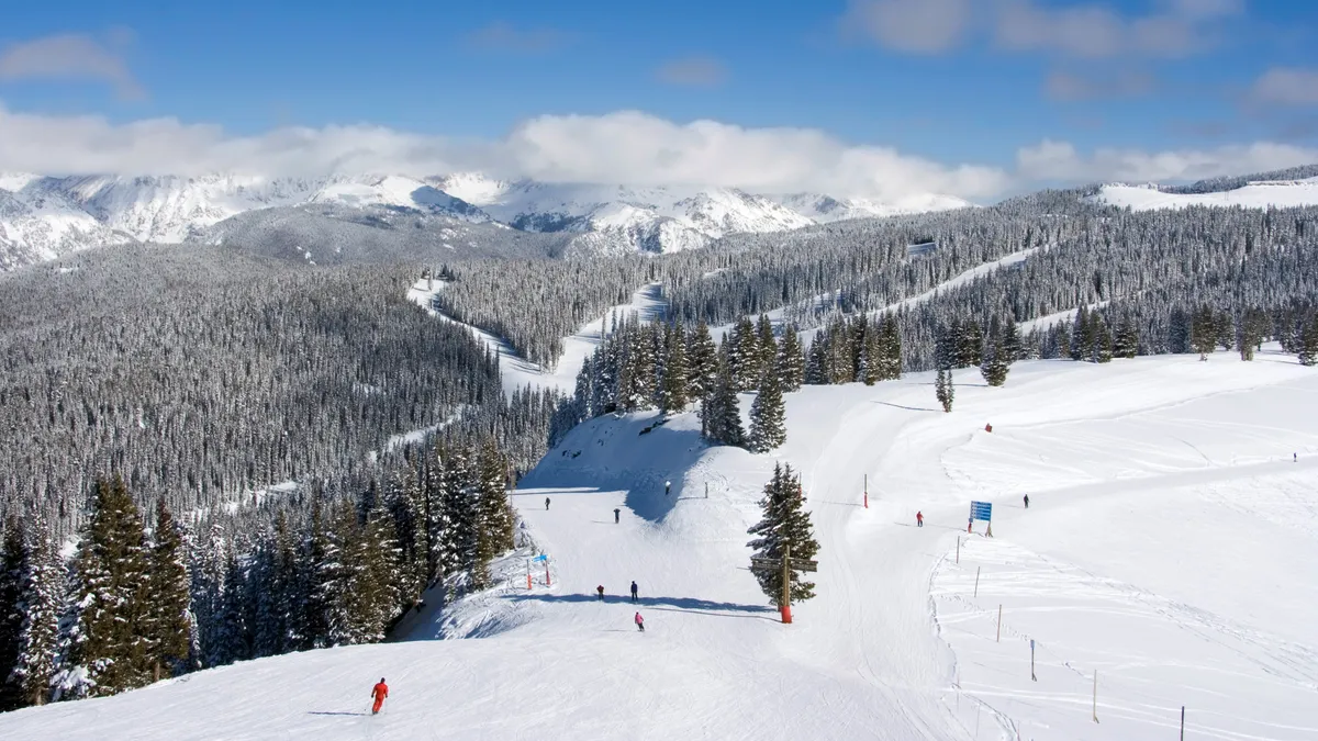
Where do avalanches occur?
- Avalanches typically occur on slopes between 20 and 55 degrees
- Most occur in the range between 30 and 45 degrees

There’s a Goldilocks zone, where the gradients are just right for a potential avalanche. On steep ground, snow tends not to accumulate in great depth and will simply slough off before a potentially hazardous amount of the white stuff forms. On gentle slopes, the anchors that hold the snow in place have an easier time battling the forces of gravity. It’s on slopes between 20 and 55 degrees that avalanches generally occur, with between 30 and 45 degrees being the main danger zone.
How to read an avalanche forecast
Here are the main 5 steps to follow when reading an avalanche forecast:
Consider conditions leading up to the day
- The planning stage is the most important when it comes to avoiding avalanches
- Keeping an eye on conditions in the weeks and days leading up to the adventure is important

The planning stage is the most important when it comes to avoiding avalanches and it starts weeks or even months before your adventure. The Be Avalanche Aware initiative from the Scottish Avalanche Information Service states that 75-80% of your avalanche hazard evaluation should be in the planning stage. Neglect this part of the process and you could end up in serious trouble.
Keeping a tab on what’s been going on with the snowpack during the winter season can help to paint a picture of what you can expect when your time in the mountains comes around. Read the forecasts, see what others are saying on online forums and speak to any friends who’ve recently been to the region you’ll be exploring.
Read the hazard level
- Forecasters provide a hazard forecast level
- There are usually five levels, from Low to Extreme

Most avalanche forecasts contain a headline hazard level. There are usually around five levels, ranging from something along the lines of Low to Very High or even Extreme.
As you’d expect, Low means that there’s little chance of an avalanche occurring and this is usually indicated by a friendly green icon. So, Go! But this doesn’t mean you should go out there blind to the risks. Low doesn't mean avalanches definitely won't occur. It’s always worth assessing the snowpack while you're out there (more on this in the Continue you evaluation while on the hill section).
The next level up is usually called something like Moderate and often has an eye-catching yellow icon. This means that considerable care should be taken when in avalanche prone terrain and you should constantly evaluate the snowpack when on the hill. While it’s only one level up from Low, avoiding Moderate terrain is the wisest course of action. As an instructor from a reputed national outdoor center once asked me: ‘If you were told that there was a moderate chance the plane you were about to get on would crash, you wouldn’t get on it, would you?”

Moving up, we’ve got the orange Considerable icon, which is usually accompanied by language like ‘dangerous’, ‘conservative design making’ and ‘very large sized natural avalanches possible’. High levels of experience are required in order to effectively evaluate the snowpack, while you should plan to avoid this kind of terrain.
The two highest warning levels are the red High and the black Very High (in Scotland) or Extreme (in the US). High means very dangerous conditions with a high likelihood of avalanches – avoid at all costs. If you see the Extreme warning, it’s probably a nice day for a bike ride or visit to the local spa.
This film from the American National Avalanche Center explains all of this in more detail:

Read the details that inform the hazard level
- There are many factors that can affect the likelihood of an avalanche
- Forecasters detail which of these are likely to be at play
- Reading the expert advice that has informed the hazard level is crucial
If you’re comfortable with the hazard level and you’re still planning on cracking on with your adventure, you need to gather as much information as you can to make informed decisions both to plan your route and while you're out in the backcountry.
There are loads of factors that can affect the likelihood of avalanches. The majority of avalanches occur during snow storms and in the two days that follow. Wind speeds above 15mph are liable to transport snow, depositing it elsewhere and creating a type of unstable snow called windslab, which is particularly prone to avalanche. The wind direction will tell you where windslab will likely accumulate.
If the weather swings from crisp and cold to warm and wet, it can negatively impact the stability of the snowpack. Read the descriptions and summaries from the experts and use them to inform your plan.
Forecasters will often draw attention to avalanche problems, which are scenarios that could lead to potential avalanches. These are factors like new snow, accumulation of wind slab, wet snow, persistent weak layers, gliding snow and cornices. An assessment of potential avalanche problems helps forecasters arrive at the avalanche hazard level.

Many forecasters provide recent photos taken while compiling their reports, while some have strategically positioned webcams. These images can help in assessing what the snow conditions are like beyond the forecaster’s written descriptions.
Some avalanche forecasts display what’s called a hazard compass rose, used to indicate which slopes are likely to be the most hazardous. The rose is a circle with the cardinal points of the compass (N, NE, E, SE, S, SW, W and NW) around the outside. The circle is divided into 8 slides – a bit like a cake – with one for each direction a slope faces. Then, within the main circle is a smaller circle, which represents ground above a certain elevation. What you end up with is 16 segments, which are then colored based on the avalanche risk for different slope aspects and at different heights.

In the example above, the avalanche hazard is expected to be considerable above 850 meters on N, NE and E facing slopes. There's also moderate avalanche risk on NW and SE slopes above 850m. There's low risk of avalanches below 850m and on W, SW and S facing slopes above 850m too.
Decide on the best course of action
- Once you’ve gathered all the information, use it to plan your route
- Plan to avoid avalanche-prone ground, including when you plot escape routes

Now that you’ve got all the information, you can apply it to your route plan in order to navigate safely and avoid potential avalanche terrain. For example, if S, SW and W facing slopes are forecasted as Low risk, but others are Moderate or Considerable, it makes sense to ascend and descend via these slopes. If your planned adventure is long or remote, you can also use this kind of information to plan safe escape routes, should you need to bail for any reason.
Of course, if the threat is consistent across all aspects on higher ground, you may choose to alter your plans altogether and avoid the mountains.
Continue your evaluation while on the hill
- 20 to 25% of avalanche evaluation takes place while out in the backcountry
- Assess whether the conditions match what was predicted in the forecast
- Look out for signs of avalanche danger and be prepared to take plan B if necessary

As mentioned, 75 to 80% of your avalanche evaluation should take place in the planning stage, which leaves 20 to 25% for when you’re out there, assessing what you can see and the terrain beneath your feet, while considering how it compares to what was forecast.
Warning signs to look out for are things like fresh avalanche debris, which indicates that slopes of a similar aspect may also be liable. Best to avoid. Or, slabs large of snow breaking away or cracking beneath your feet, indicating an unstable snowpack. Listen out for a distinctive whoomping sound, another indication of instability. If you encounter these, retreat.
If the windspeeds are more than what was forecasted, consider what this might mean in terms of freshly deposited windslab and where it’s likely to accumulate. Consider whether this should change your plan. While undoubtedly beautiful, snow being whipped around by the wind at your feet is a sure sign that unstable snow is accumulating. If visibility is poor and you’re unable to properly assess conditions, perhaps opt for a more conservative plan B.
All of these considerations and decisions require a certain level of experience, which is why it’s always great to head out with a guide or book a course if you're new to the winter environment.
Forecast providers in the US
America’s varied and spectacular mountain landscapes are arguably even more awe-inspiring in winter. Their siren song is irresistible to many, yet with its beauty comes its danger. Snow avalanches kill about 45 people in the American backcountry each year, so an understanding of the risks and knowing how to read an avalanche forecast are clearly important.
Avalanche.org is a great source of information. A partnership between the American Avalanche Association (A3) and the US Forest Service National Avalanche Center (NAC), it consolidates data from various professional forecast centers to provide real-time guidance for winter explorers. The National Danger Map provides a quick overview of the hazard level across many of Western States’ popular mountain regions.
From the map, you can click into and access regional forecasts, such as the Colorado Avalanche Information Center or the Northwest Avalanche Center for the likes of the Olympic, North Cascades and Mount Rainier National Parks.
Forecast providers in the Alps

Unsurprisingly given their popularity, the Alps are well served by a range of Avalanche forecasters. With summers getting hotter and the weather becoming more and more unpredictable, being avalanche aware while exploring Western Europe’s greatest mountains has never been so important.
A good place to start is the Avalanche.report website, which provides a handy map of the Alps on its homepage, with links to various services across the range. The site has detailed information for Austria’s Tyrol, as well as South Tyrol and Trentino in Italy – these were the regions directly involved in launching the site.
However, click on the relevant part of the map and you can find all the information you’d need, from the SLF in Swizerland and its White Risk portal, to Meteo Montagne for the French Alps.
Forecast providers in the UK

While avalanches can, and do, occur in parts of Wales, England and Northern Ireland, the vast majority of avalanche activity in the UK occurs in the Scottish Highlands.
Although diminutive compared to the giants of the Alps, Rockies, Andes and Himalayas, Scotland’s mountains are serious stuff in winter. From the vast, sub-Arctic Cairngorm plateau to the pointier peaks in the west, Scotland’s Bens, Sgúrrs and Stobs are just high enough that they often freeze in winter but not so high that it’s a permanent state of affairs. This leads to repeated freeze-thaw cycles, creating the kind of terrain that winter climbers love but also conditions that are ripe for avalanche.
This is where the Scottish Avalanche Information Service (SAIS) comes in, producing daily reports throughout the winter season for the country’s most popular regions. They arrive at their forecasts through a blend of expert experience, in-the-field analysis and comparison with the Met Office weather forecast.