
If you were totally ignorant of England’s geography and new to its national parks, you’d probably first head for the Peak District in search of its tallest mountains. You’d find relatively nice hills and some high moorland to explore in “the Peaks”, named so for the Anglo-Saxon Pecsaetan tribe who settled there and not for its absent array of Matterhorns. You would not, however, find any mountains.
No, to seek the highest peaks, to find the country’s mountains, you have to head to the Lake District. Here, all of England’s tallest mountains are found – forged by ancient volcanos, carved by glaciers, resplendently rocky and rising above Cumbria’s famously picturesque green dales. To be fair to whoever decided that this exquisite region should be called the Lake District, there are admittedly quite a few lakes here, including England’s largest, Windermere, and its deepest, Wast Water. Nevertheless, this land of tightly knit fells could have very easily been the Mountain District, or the Fell District… or even the Peak District.
For this feature on England’s 5 tallest mountains, we asked our Cumbrian-born mountain expert to delve into what it is that characterizes these famous peaks, as well as detailing a few of the national park’s other big hitters.
England’s 5 tallest mountains
1) Scafell Pike: The rugged, rocky and remote crown of England, at 3,209 feet (978 meters), is on many bucket lists.
2) Scafell: The Pike’s rockier and arguably fiercer neighbor, Scafell is home to classic rock climbing routes.
3) Helvellyn: A legendary mountain that’s third in the list of England’s tallest mountains, and the Lake District’s most popular summit objective.
4) Skiddaw: The noble and rounded high point of Lakeland’s oldest mountain range is a familiar sight above Keswick.
5) Great End: The northern terminus of the Scafell Range is known for the intimidating cliffs of its north face.
A quick word before eagle-eyed lovers of Lakeland spit their tea all over their keyboard in fury at the omission of Ill Crag (3,067 feet / 935 meters) and Broad Crag (3,064 feet / 934 m), two peaks of minor prominence that lie between Scafell Pike and Great End in the Scafell Range. While these would technically qualify as the fourth and fifth highest mountain peaks in England, they’re not substantially prominent nor removed enough from Scafell Pike for me to seriously consider them as mountains in their own right.
After all, the great fellsman, guidebook writer and illustrator Alfred Wainwright saw fit not to include them as separate fells in his classic Pictorial Guides to the Lakeland Fells. If that’s fine by Wainwright, it’s fine by me.
Meet the expert

Qualified Mountain Leader and avid hiker Alex was born in Carlisle, just a stone’s throw from the Lake District National Park. It’s a region that’s very close to his heart and he’s spent many happy days wondering the fells. He’s visited the summits of England’s highest mountains on countless occasions.
Scafell Pike
Height: 3,209 feet / 978 meters
Location: Scafell Range, Southern Fells, Lake District National Park

England’s highest and most mountainous upland is the Scafell Range, a great system of ridges and peaks in the Lake District’s Southern Fells. The Scafells are relatively remote and are often hidden from view – or sometimes inconspicuous when they do form part of the skyline. This is especially true of Scafell Pike, a mountain that only reveals its secrets to those that make the effort to scale its rocky zenith. Despite its relative remoteness, it’s thought that around 250,000 folk climb it every year. Well, it is England’s tallest mountain, after all.
Now, before we go any further, Scafell is pronounced Skaw-fell, not Ska-fell. Maybe it’s because I’m originally from this neck of the woods or perhaps it’s the pernickety part of my character but it irks me when folk get this wrong. And most do.

Moving swiftly on. Scafell Pike is the remaining high point of what was, 450 million years ago, the gigantic Scafell Volcano, one of several that existed in the region. An intensely violent period of geological activity formed the rhyolite of the mountain’s crags, while also creating the granite foundations that we have to thank for stopping the Lake District’s meres, waters and lakes from draining away.
There are many ways up Scafell Pike, the direct ascent from remote Wasdale Head being the quickest. However, special mention should go to Upper Eskdale, a breathlessly beautiful wilderness that’s way off the beaten path. Any adventure onto the mountain from here is unforgettable and you’re unlikely to meet many others until you reach the summit.
Scafell
Height: 3,163 feet / 964 meters
Location: Scafell Range, Southern Fells, Lake District National Park

As the crow flies, England’s second tallest mountain is around a mile from its highest, and the two share, among other things, the same name. When people say, “I’m off to climb Scafell,” they usually mean Scafell Pike. Were it further removed from its parent peak, Scafell would see many more pairs of hiking shoes upon its summit. Then there’s the fact that getting between England’s two highest mountains is far from straightforward.
The two are separated by a short ridge, Mickledore, an 831-meter low point squeezed between England’s tallest mountains. The way to Scafell Pike from Mickledore is simple enough, merely a strenuous pull up a boulder field. However, getting to Scafell is another matter entirely. Here, at Mickledore, the mountain rises in the most brutal display of mountain muscle anywhere in England. The great crags of its East Buttress are an almost impenetrable fist, barring progress towards the summit and frustrating the impatient peak bagger.

A tricky rock climb, Broad Stand, breaches these defences, but is a dangerous proposition for the unroped. For hikers, a much lengthier detour is prudent, either south to Foxes Rake or north to seek out the excitement of Lord’s Rake, with the option of the West Wall Traverse, two hiking routes that provide an intimate acquaintance with Scafell’s tremendous rock scenery.
These great crags, on the north and east side of the mountain, are formed from rhyolitic tuffs, the result of great eruptions of ash and pumice when the bones of the Scafells were put in place, 450 million years ago. Many classic rock climbs are found on these cliffs. The west and south sides of Scafell are much gentler and it’s here that the easier hiking trails to the summit are found.
Helvellyn
Height: 3,117 feet / 950 meters
Location: Helvellyn Range, Eastern Fells, Lake District National Park

Helvellyn might be England’s most popular mountain, though it’s a close-run thing between it and Scafell Pike when it comes to the most climbed. It’s hard to say which sees the most people as it’s not as if there’s a turnstile counting the number of hiking boots that set out onto the trails.
There are two primary reasons that Helvellyn may attract more folk. One, it’s more accessible than the remote Scafells – the Helvellyn Range cleaves the national park in two from north to south and is just a short drive from the tourist towns of Keswick and Ambleside. Two, it features Britain’s most renowned mountain route – a cracker of a ridge walk and one that was recently voted as the UK’s favorite walk on national TV: the famous Striding Edge.

Striding Edge is a narrow, rocky arête that attracts adventurous hillwalkers from far and wide. While technically straightforward – barely a grade one scramble – the Edge is many people’s first taste of scrambling and offers an exciting and airy traverse that most find exhilarating. Nevertheless, the sheer number of hikers that take on the ridge mean that it’s an accident hotspot and fatalities do occur, some from heart attacks, others from falls. This gives Striding Edge its formidable reputation and it’s often cited, perhaps unfairly, as one of the world’s most dangerous hiking trails.
Striding Edge is the southern arm of the great glacial cove on the mountain’s east side. The summit stands proud at the head of the immense scoop, while nestled in the bed of the cove is the delightful pool of Red Tarn. The northern arm is another scrambling ridge, Swirral Edge, which leads to the delightfully pointed peak of Catstycam. Swirral is less serious than Striding but is particularly steep in its upper reaches. Both are full-on mountaineering propositions under winter conditions, as are the gullies of Browncove Crags, to the northwest of Helvellyn’s summit.

In contrast to its notoriously narrow edges, the top of Helvellyn is broad and relatively gentle. So much so, it was an acceptable site for pilot Bert Hinkler and Manchester-based aviator John Leeming to attempt to land an Avro-Gosport biplane in 1926. The successful landing on December 22 of that year was described as a “fairly peaceful and comforting experience” according to an achieve news piece in the Guardian.
From this popular summit, one can survey the great tangle of fells that comprise the western and more mountainous end of the Lake District, with virtually every high peak in the national park on display – on a good day, of course.
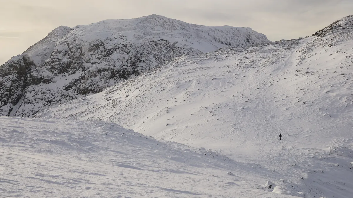
Skiddaw
Height: 3,054 feet / 931 meters
Location: Skiddaw group, Northern Fells, Lake District National Park

The domed summit of Skiddaw is the loftiest point in the Lake District’s Northern Fells, a cluster of uplands composed of the oldest rock in the national park. Lakeland’s central mountain landscapes, where the Scafells and Helvellyn are found, were forged of volcanic rock, the result of intense geologic activity around 450 million years ago. Whereas Skiddaw and its neighbors were laid down around 50 million years earlier from a foundation of mudstone, siltstone and greywacke sandstone known as Skiddaw Slate.
This is evident in the contrasting character of the Skiddaw group, a range of rounded fells, mostly devoid of crags and gentle in appearance. Climbers should apply elsewhere, though there’s plenty to please hikers, runners and wild campers here. Of all the national park’s highest summits, Skiddaw is the most accommodating and it’s easily accessible from Keswick, the honeypot town the mountain watches over protectively.

Undoubtedly the finest route to the summit is via Long Side Edge, a limb to the west of the main summit that makes for a superb trail run. Skiddaw’s eastern hinterland, known as Back o’ Skidda is a tranquil and remote setting, hemmed in by fells and with no roads to speak of for many miles. Here you’ll find Skiddaw House, Britain’s highest hostel and a marvellous place to escape from everyday cares.
Great End
Height: 2,985 feet / 910 meters
Location: Scafell Range, Southern Fells, Lake District National Park

The appropriately named Great End is the northern terminus of the Scafell Range’s high spine. It’s named so for its northeast-facing cliffs, surely one of the Lake District’s most impressive crags. Cut by impressive gullies, this is a renowned winter climbing spot, though it’s also been the site of many avalanches down the years.
The bulk of Great End is one of the dominant features above the Sty Head Pass, an ancient route between the valleys of Wasdale and Borrowdale and one that today gives access to some of the finest hiking in England. From Styhead Tarn, towards the top of the pass, Great End appears as a rounded dome, with grassy lower flanks making way to exposed rhyolite in its upper reaches.
Great End’s summit plateau is broad and rocky, providing excellent views along England’s highest mountain range to Scafell Pike. Linking the two summits is straightforward enough, entailing a rough hike and some boulder hopping – nothing like the trials of getting between Scafell Pike and Scafell.
Other much-loved mountains in the Lake District

Just missing out on the top 5 is Bowfell, a 2,959 feet / 902-meter summit at the head of Great Langdale. A great favorite for many, Bowfell’s pyramidal zenith is a conspicuous sight from many of Lakeland’s other high summits. The great guidebook writer and illustrator Alfred Wainwright named the fell among his best half-dozen, along with Scafell Pike, Helvellyn and neighboring Crinkle Crags, as well as Great Gable and Blencathra, two mountains we’ll come to in a moment. Bowfell’s northeast facing crags contain much of its interest, where hikers will find the exciting Climber’s Traverse path and the Great Slab, a spectacular angled slab.

The most dramatically prominent mountain in the Lakes is undoubtedly Great Gable, England’s seventh tallest mountain, at 2,949 feet / 899 meters. It’s a peak that commands attention from whichever angle you view it from, though it looks its best, every bit the classically pointed peak, from the southwest. From this direction, it’s the central feature in the famous view along Wast Water – frequently cited as England’s most beautiful vista. The crags on its southern flanks are home to some renowned rock climbs, including the first recorded free solo in history. In 1886, pioneering British climber Walter Parry Haskett Smith sent the the now iconic Napes Needle, etching his name into the history of rock climbing.

Finally, we come to Skiddaw’s neighbor, Blencathra, England’s 18th highest summit, at 2,848 feet / 868 meters. Considered by many to be the nation’s finest mountain, Blencathra is characterized by a system of fine ridges that converge towards its highest point and its saddle-shaped summit platform – a feature that gives it the alternative name Saddleback.
The central ridge, Halls Fell, is a magnificent objective that Alfred Wainwright named as ‘positively the finest way to any mountain top in the district’. However, it’s second in fame to another one of Blencathra’s ridges, the notorious and admittedly thrilling Sharp Edge. Like Striding Edge on Helvellyn, this grade one scramble is another accident blackspot and is best avoided in wet conditions.

